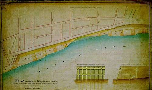
Plan of the project to widen the levee of the Second Municipality in order to facilitate the loading and unloading of steamboats, flatboats and other small vessels, Joseph Pilie, June 15, 1827. The plan also provides a detailed view of the wooden revetments used, quite successfully, to reinforce the levee within the City's limits.As the plan shown here indicates, the levee at New Orleans was, and is, something quite different from the seemingly endless green hill that parallels the Mississippi above and below the Crescent City. The city's levee was in some ways as much a quay (i.e., "an artificial bank or landing-place ... lying along or projecting into a navigable water for convenience of loading and unloading ships"--Oxford English Dictionary) as it was an impediment against inundation by the river's angry waters. Not that it did not succeed admirably in the latter role. New Orleans has never been flooded by a break in the river levee within the limits of the city proper. Flood waters have rushed through crevasses in neighboring Jefferson Parish and then seethed into the city from the west, but our own levees have held for 280 years.[City Surveyor's Office Records]
But much of the New Orleans levee is covered by the city's wharves and has been for many years. In earlier times the wharves were anchored in the levee and angled out into the river. Wharves were the connections between water craft and the shore and the levee was the place where cargoes were kept before or after being loaded onto or unloaded from ships. The city's wharves were constantly being rebuilt and modernized and, by the late 19th century at least, the old style of wharf had been replaced by structures that lay alongside, rather than perpendicular to, the levee. By 1939, the Corps of Engineers could write in its Port Series No. 5 that "Practically all of the wharves along the east or left bank of the Mississippi River parallel the river bank, thereby nearly forming a continuous quay for a distance of approximately 10 miles."
 Next Page
Back to River Exhibit Main Page
iw/we 5/1998