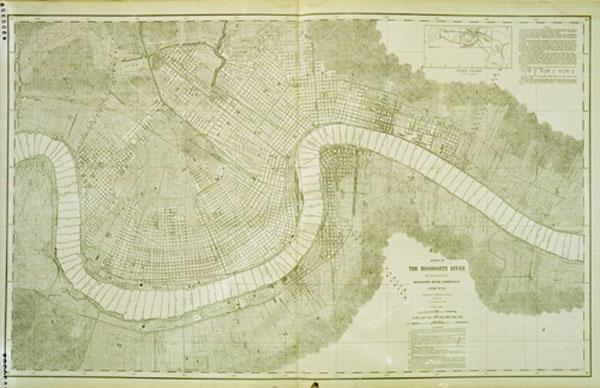
This map of the City of New Orleans appears as chart #76 in the second of two massive volumes charting the course of the River from Newport, Minnesota (just south of St. Paul) to the Gulf of Mexico.The Mississippi has given much to New Orleans--its wealth, its diverse population, and its most valuable real estate. It has also given, through its predominant geographical feature at this location, our town's most enduring and most descriptive nickname--the Crescent City. The aptness of this cognomen is well demonstrated by the 1890s map displayed here. It shows, encompassed within the Mississippi's great bend, all of the elements that make the intersection of the river with the city of such overwhelming significance--the extensive system of wharves, the various ferry lines that connected the two halves of the city, the numerous railroad lines coming into New Orleans to take advantage of the port and its products (curiously, though, the map does not show the train ferries then in operation).[Survey of the Mississippi River made under the direction of the Mississippi River Commission, 1874-1894.]
Two other features of this map remind us of the tremendous challenge inherent in controlling and managing the mighty river. It indicates, just across from Audubon Park, the location of the Ames Crevasse where, in 1893, the Mississippi flooded the west bank. The map also includes river soundings, evidence of the ongoing task of keeping the river deep enough to allow vessels of ever-increasing size to travel through the harbor and land at its docks. Whereas the responsibility for flood control and navigational improvements along the river had long ago belonged to the City Surveyor of New Orleans, they were by the turn of the century the province of the U.S. Army Corps of Engineers.
 Next Page
Back to River Exhibit Main Page
iw/we 5/1998