|
|
| PANEL IMAGES |
Introduction Main Library Site | Eye, Ear, Nose & Throat Hospital Pythian Temple | Duncan Plaza Charity Hospital | Rampart Street |
| Click on the images to view a larger version. When the image loads, click it again to magnify further. Use your BACK button to return to this page. |
|
| The three images below comprise the title panels in the physical exhibit on view in the Main Library. |
 |
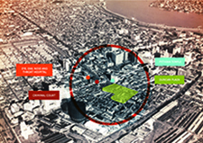
Brooke H. Duncan, manager of the Cityís Real Estate Utility Department, apparently had this photograph of the proposed Civic Center area taken by the Abrams Aerial Survey Corp., ca. 1946. We know that Abrams did a survey of the entire metropolitan area in that year, at a cost of $34,734.86, but this does not appear to be a product of that project.
City Planning Commission, Subject Files, Folder 434 |
 |
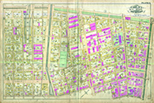
The vicinity of Common and Basin (and beyond), ca. 1880. P. Casseís Granite & Marble Works had just moved to Common Street in October 1879, but Roberts & Co., the soda water factory, the gas works, and Charity Hospital had all been in the neighborhood for years.
Robinsonís Atlas of the City of New Orleans, Louisiana, 1883, Plate 4 |
 |
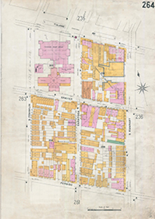
The City was interested in the Common & Basin area for public purposes as early as 1888 when it began renting a building on Basin Street from John H. Wilberding for use by the First Recorders Court. In November 1891, ordinance #5785 (Council Series) authorized the purchase of seven lots in the square bounded by Tulane, Franklin, Basin, and Gravier Streets from five owners (including Wilberding) for a total of $68,500. By 1908 the Criminal Court House and Parish Prison built on those lots dominated the neighborhood. Interestingly, the Pythian Temple is shown across Basin Street even though it had not yet been built. A notation on the map indicates that the information about the building was taken from the plans.
Sanborn Map Company, Insurance Maps of New Orleans, Louisiana, 1908, Volume 3, Sheet 264 |
|
9/5/2014 -- iw |
|